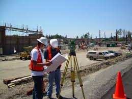
ALTA Dallas – Fort Worth, TX
 The American Land Title Association or commonly called ALTA, which was founded in 1907, is a national trade association which represents real estate attorneys, title insurance companies, title searchers, title and settlement agencies, and independent abstracters. The ALTA Board of Governors is responsible for setting organization policy, supervising the work of its committees, and handling the financial health of the association. ALTA protect property owners and mortgage lenders by conducting inspections, title searches, finalizing and issuing title insurance to avoid losses due to defective titles.
An ALTA/ACSM land survey must conform to the strict standards jointly established by the American Land Title Association and the American Congress on Surveying and Mapping (ACSM). ALTA surveying is generally done for commercial properties and is generally much expensive than other types of land surveys. AN ALTA/ACSM land survey is often required when purchasing real estate property or if a company is situated outside the state where the property is located.
The main goal of ALTA land survey is to set national standards regarding land survey information. In addition, the ALTA/ACSM along with the National Society of Professional Surveyors (NSPS) created an “Accuracy Standards” to handle issues concerning Closure and Distance Requirements and Minimum Angle and Positional Uncertainty for ALTA/ACSM Land Title Surveys. The ALTA/ACSM Land Title Survey includes the names of the seller, buyer, lender, insurance company, and Title Company.
Before measuring the property, an ALTA/ACSM land surveyor must first do a thorough research for any possible issues by looking at the local or municipal records, as well as examine the exisiting title commitment. The following information is needed for an ALTA/ACSM land survey:
- Access to public roads and utilities
- Any possible encroachments
- Areas of ownership
- Easements and/or improvements that may be advantageous or disadvantageous to the property
- Flood zones
- Owners of the adjacent property
- Rights of way
- Water boundaries inside the property
- Zoning setbacks
- Other vital information with regards to property ownership
A land survey map is drawn according to ALTA specifications after the survey and location data are accomplished for the Title Company and/or Lender for issuing the title or mortgage insurance. The ALTA land surveyors work and the title insurance company rely on each other’s work to achieve an extensive survey.
Summary:
An ALTA land survey is generally a requirement before any title company or lending establishment seal a real estate transaction. This type of survey is usually needed by commercial properties to present to the title company the details required for insuring the title to the land and making any necessary improvements for commercial development. The survey shows information such as rights of ways, easements, zoning restrictions, improvements, and other features that may affect property ownership.
To provide the legal description of the property as well as indicate any easements or restrictions of record involving the property, a most recent title commitment is necessary for the completion of an ALTA land survey. The ALTA land surveyor explains these details graphically on a survey map as well as certify the accuracy of the map to the buyer, the lender, and the title company.
